

Archivos suplementarios
Palabras clave
coseismic-landslides
Scenario
Natural hazards
Costa Rica
Terremotos
Deslizamientos-cosísmicos
Escenarios
Peligros
Costa Rica
Cómo citar
Resumen
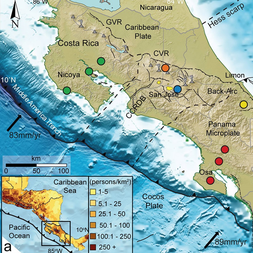
Se muestran las capacidades de la modelación de escenarios de terremotos hipotéticos como una herramienta para la evaluación de la amenaza de deslizamientos cosismicos. El entorno geológico - tectónico de Costa Rica y sus características orográficas resultaron ideales para probar esta técnica. El modelo trabaja con: pendiente del terreno, velocidad máxima del suelo (VMS), índice topográfico compuesto (ITC), magnitud y profundidad del sismo disparador para pronosticar la probabilidad de deslizamientos y sus efectos. Se examinaron 5 ambientes tectónicos, eventos de subducción en las penínsulas de (1) Nicoya y (2) Osa respectivamente, (3) eventos intraplaca bajo la Cordillera Volcánica Central (CVC) y el (4) Cinturón Deformado del Centro de Costa Rica y (5) eventos en el tras-arco en el Caribe. Los resultados muestran variabilidad en los valores de umbral de pendientes VMS e ITC dependiente del ambiente modelado, para producir probabilidades de disparo de deslizamientos superiores al 10 %. La magnitud del sismo es siempre el principal controlador de la probabilidad máxima de ocurrencia de deslizamientos. Se validaron las predicciones del modelo comparando los resultados con inventarios de deslizamientos observados en los terremotos de Cinchona (2009) y Limón (1991), donde más del 70% de los deslizamientos ocurrieron en zonas con una probabilidad > 20%. Finalmente utilizamos un modelo global de impacto de deslizamientos para predecir los rangos de exposición y letalidad para cada escenario, revelando que los terremotos de tamaño moderado en CDCCR y CVC y los grandes terremotos de subducción representan un peligro potencial significativo para la población de Costa Rica.
Citas
Adamek, S., Tajima, F., & Wiens, D. A. (1987). Seismic rupture associated with subduction of the Cocos Ridge. Tectonics, 6(6), 757-774.
Allen, T. I., Marano, K. D., Earle, P. S., & Wald, D. J. (2009). PAGER-CAT: A composite earthquake catalog for calibrating global fatality models. Seismological Research Letters, 80(1), 57-62.
Alonso‐Henar, J., Montero, W., Martínez‐Díaz, J. J., Álvarez‐Gómez, J. A., Insua‐Arévalo, J. M., & Rojas, W. (2013). The Aguacaliente Fault, source of the Cartago 1910 destructive earthquake (Costa Rica). Terra Nova, 25(5), 368-373.
Babayev, G., Ismail-Zadeh, A., & Mouël, J. L. L. (2010). Scenario-based earthquake hazard and risk assessment for Baku (Azerbaijan). Natural Hazards and Earth System Sciences, 10(12), 2697-2712.
Baker, J. W. (2008). An introduction to probabilistic seismic hazard analysis (PSHA). White paper version, 1, 72.
Bird, J. F., & Bommer, J. J. (2004). Earthquake losses due to ground failure. Engineering Geology, 75(2), 147-179.
Bozzano, F., Esposito, C., Martini, G., Martino, S., Prestininzi, A., Rinaldis, D., ... & Mugnozza, G. S. (2013). Earthquake-reactivated landslide scenarios in Southern Italy based on spectral-matching input analysis. Bulletin of Earthquake Engineering, 11(6), 1927-1948.
Budimir, M. E. A., Atkinson, P. M., & Lewis, H. G. (2014). Earthquake-and-landslide events are associated with more fatalities than earthquakes alone. Natural hazards, 72(2), 895-914.
Camacho, E., Hutton, W., & Pacheco, J. F. (2010). A new look at evidence for a Wadati–Benioff zone and active convergence at the north Panama deformed belt. Bulletin of the Seismological Society of America, 100(1), 343-348.
Carvajal-Soto, L. A., Ito, T., Protti, M., & Kimura, H. (2020). Earthquake potential in Costa Rica using three scenarios for the Central Costa Rica deformed belt as western boundary of the Panama microplate. Journal of South American Earth Sciences, 97, 102375.
DeMets, C., Gordon, R. G., & Argus, D. F. (2010). Geologically current plate motions. Geophysical Journal International, 181(1), 1-80.
Detweiler, S. T., & Wein, A. M.. (2017). The HayWired earthquake scenario. U.S. Geological Survey Scientific Investigations Report 2017–5013. https://doi.org/10.3133/sir20175013
Fernández, M., & Rojas, W. (2000). Faulting, shallow seismicity and seismic hazard analysis for the Costa Rican Central Valley. Soil dynamics and earthquake engineering, 20(1-4), 59-73.
Fisher, D. M., Gardner, T. W., & Marshall, J. S. (1994). Kinematics associated with late Cenozoic deformation in central Costa Rica: Western boundary of the Panama microplate. Geology, 22(3), 263-266.
GeoHazards International (GHI). (2018). Earthquake Scenarios, Nepal. https://www.geohaz.org/earthquake-scenarios-nepal
Harp, E. L., Wilson, R. C., & Wieczorek, G. F. (1981). Landslides from the February 4, 1976, Guatemala earthquake (No. 551.3 HAR). US Government Printing Office.
Hayes, G. P., Moore, G. L., Portner, D. E., Hearne, M., Flamme, H., Furtney, M., & Smoczyk, G. M. (2018). Slab2, a comprehensive subduction zone geometry model. Science, 362(6410), 58-61.
Hernández, G., Vahrson, W., & Ruiz, A. (1992). Deslizamientos producto del terremoto (4-22-91)/Landslides produced by the 22 Apr 1991 earthquake. Escuela de Ciencias Geográficas, Universidad Nacional de Costa Rica.
Jibson, R. W., Harp, E. L., & Michael, J. A. (2000). A method for producing digital probabilistic seismic landslide hazard maps. Engineering geology, 58(3-4), 271-289.
Keefer, D. K. (1984). Landslides caused by earthquakes. Geological Society of America Bulletin, 95(4), 406-421.
Konovalov, A., Gensiorovskiy, Y., Lobkina, V., Muzychenko, A., Stepnova, Y., Muzychenko, L., Stepnov, A., & Mikhalyov, M. (2019). Earthquake-induced landslide risk assessment: An example from Sakhalin Island, Russia. Geosciences, 9(7), 305.
Kritikos, T., Robinson, T. R., & Davies, T. R. (2015). Regional coseismic landslide hazard assessment without historical landslide inventories: A new approach. Journal of Geophysical Research: Earth Surface, 120(4), 711-729.
Kumar, S., Gupta, V., Kumar, P., & Sundriyal, Y. P. (2021). Coseismic landslide hazard assessment for the future scenario earthquakes in the Kumaun Himalaya, India. Bulletin of Engineering Geology and the Environment, 1-17.
Liu, J., Shi, J., Wang, T., & Wu, S. (2018). Seismic landslide hazard assessment in the Tianshui area, China, based on scenario earthquakes. Bulletin of Engineering Geology and the Environment, 77(3), 1263-1272.
Marano, K. D., Wald, D. J., & Allen, T. I. (2010). Global earthquake casualties due to secondary effects: a quantitative analysis for improving rapid loss analyses. Natural hazards, 52(2), 319-328.
Marshall, J. S., Fisher, D. M., & Gardner, T. W. (2000). Central Costa Rica deformed belt: Kinematics of diffuse faulting across the western Panama block. Tectonics, 19(3), 468-492.
Martino, S., Battaglia, S., D’alessandro, F., Della Seta, M., Esposito, C., Martini, G., Pallone, F., & Troiani, F. (2020). Earthquake-induced landslide scenarios for seismic microzonation: Application to the Accumoli area (Rieti, Italy). Bulletin of Earthquake Engineering, 18(12), 5655-5673.
Martino, S., Battaglia, S., Delgado, J., Esposito, C., Martini, G., & Missori, C. (2018). Probabilistic approach to provide scenarios of earthquake-induced slope failures (PARSIFAL) applied to the alcoy basin (South Spain). Geosciences, 8(2), 57.
MATLAB. (2020). 9.9.0.1570001 (R2020b). The MathWorks Inc.
Mendoza, C., & Nishenko, S. (1989). The north Panama earthquake of 7 September 1882: Evidence for active underthrusting. Bulletin of the Seismological Society of America, 79(4), 1264-1269.
Mora, S., & Mora, R. (1994). Los deslizamientos causados por el terremoto de Limón: Factores de control y comparación con otros eventos en Costa Rica. Revista Geológica de América Central, Volumen Especial Terremoto de Limón, 139-152.
Nayek, P. S., & Gade, M. (2021). Seismic landslide hazard assessment of central seismic gap region of Himalaya for a M w 8.5 scenario event. Acta Geophysica, 1-13.
Newmark, N. M. (1965). Effects of earthquakes on dams and embankments. Geotechnique, 15(2), 139-160.
Nowicki Jessee, M. A., Hamburger, M. W., Allstadt, K., Wald, D. J., Robeson, S. M., Tanyas, H., Hearne, M., & Thompson, E. M. (2018). A global empirical model for near‐real‐time assessment of seismically induced landslides. Journal of Geophysical Research: Earth Surface, 123(8), 1835-1859.
Nowicki Jessee, M. A., Hamburger, M. W., Ferrara, M. R., McLean, A., & FitzGerald, C. (2020). A global dataset and model of earthquake-induced landslide fatalities. Landslides, 17(6).
Protti, M., Gu, F., & McNally, K. (1994). The geometry of the Wadati-Benioff zone under southern Central America and its tectonic significance: Results from a high-resolution local seismographic network. Physics of the Earth and Planetary Interiors, 84(1-4), 271-287.
QGIS.org. (2020). QGIS Geographic Information System. QGIS Association. http://www.qgis.org
Quesada-Román, A. (2021). Landslide risk index map at the municipal scale for Costa Rica. International Journal of Disaster Risk Reduction, 56, 102144.
Rao, V. D., & Choudhury, D. (2021). Deterministic Seismic Hazard Analysis for the Northwestern Part of Haryana State, India, Considering Various Seismicity Levels. Pure and Applied Geophysics, 178(2), 449-464.
Robinson, T. R. (2020). Scenario ensemble modelling of possible future earthquake impacts in Bhutan. Natural hazards, 103(3), 3457-3478.
Robinson, T. R., Davies, T. R. H., Wilson, T. M., & Orchiston, C. (2016). Coseismic landsliding estimates for an Alpine Fault earthquake and the consequences for erosion of the Southern Alps, New Zealand. Geomorphology, 263, 71-86.
Robinson, T. R., Rosser, N. J., Densmore, A. L., Oven, K. J., Shrestha, S. N., & Guragain, R. (2018). Use of scenario ensembles for deriving seismic risk. Proceedings of the National Academy of Sciences, 115(41), E9532-E9541.
Rodriguez-Peces, M. J., Garcia-Mayordomo, J., Azanon, J. M., & Jabaloy, A. (2011). Regional hazard assessment of earthquake-triggered slope instabilities considering site effects and seismic scenarios in Lorca Basin (Spain). Environmental & Engineering Geoscience, 17(2), 183-196.
Ruiz, P., Carr, M. J., Alvarado, G. E., Soto, G. J., Mana, S., Feigenson, M. D., & Sáenz, L. F. (2019). Coseismic landslide susceptibility analysis using LiDAR data PGA attenuation and GIS: the case of Poás volcano, Costa Rica, Central America. In F. Tassi, O. Vaselli & R. Mora Amador (eds), Poás Volcano. Active Volcanoes of the World (pp. 79-118). Springer. https://doi.org/10.1007/978-3-319-02156-0_4
Salinas-Jasso, J. A., Ramos-Zuñiga, L. G., & Montalvo-Arrieta, J. C. (2019). Regional landslide hazard assessment from seismically induced displacements in Monterrey Metropolitan area, Northeastern Mexico. Bulletin of Engineering Geology and the Environment, 78(2), 1127-1141.
Seal D. M., Jessee A. N., Hamburger M. W., & Allstadt K. E. (2020). Comprehensive Global Database of Earthquake-Induced Landslide Events and Their Impacts. U.S. Geological Survey data release, https://doi.org/10.5066/P9NWIRZZ
Spence, R., So, E., Ameri, G., Akinci, A., Cocco, M., Cultrera, G., Franceschina, G., Pacor, F., Pessina, V., Lombardi, A. M., Zonno, G., Carvalho, A., Campos, A., Coelho, E., Pitilakis, K., Anastasiadis, A., Kakderi, K., Alexoudi, M., Ansal, A., Erdic, M., Tonuk, G., & Demircioglu, M. (2007). Earthquake disaster scenario prediction and loss modelling for urban areas. IUSS Press.
Suárez, G., Pardo, M., Domínguez, J., Ponce, L., Montero, W., Boschini, I., & Rojas, W. (1995). The Limón, Costa Rica earthquake of April 22, 1991: Back arc thrusting and collisional tectonics in a subduction environment. Tectonics, 14(2), 518-530.
Tajima, F., & Kikuchi, M. (1995). Tectonic implications of the seismic ruptures associated with the 1983 and 1991 Costa Rica earthquakes. Geologic and tectonic development of the Caribbean Plate boundary in southern Central America, 295, 327.
USGS. (2017). ANSS comprehensive earthquake catalog (ComCat). https://earthquake.usgs.gov/data/comcat/
von Huene, R., Ranero, C. R., Weinrebe, W., & Hinz, K. (2000). Quaternary convergent margin tectonics of Costa Rica, segmentation of the Cocos Plate, and Central American volcanism. Tectonics, 19(2), 314-334.
Worden, C. B., & Wald, D. J. (2016). ShakeMap Manual.Technical Manual, users guide. USGS.
Wyss, M. (2006, May). The Kashmir M7. 6 shock of 8 October 2005 calibrates estimates of losses in future Himalayan earthquakes. In B. Van de Walle & M. Turoff (eds), Proceedings of the 3 rd International ISCRAM Conference (pp. 1-5). ISCRAM.
Yue, H., Lay, T., Schwartz, S. Y., Rivera, L., Protti, M., Dixon, T. H., Owen, S., & Newman, A. V. (2013). The 5 September 2012 Nicoya, Costa Rica Mw 7.6 earthquake rupture process from joint inversion of high‐rate GPS, strong‐motion, and teleseismic P wave data and its relationship to adjacent plate boundary interface properties. Journal of Geophysical Research: Solid Earth, 118(10), 5453-5466.
##plugins.facebook.comentarios##

Esta obra está bajo una licencia internacional Creative Commons Reconocimiento-NoComercial-CompartirIgual 3.0.
Derechos de autor 2022 Dylan M. Seal, M. Anna Nowicki Jessee, Michael W. Hamburger, Paulo Ruiz