Abstract
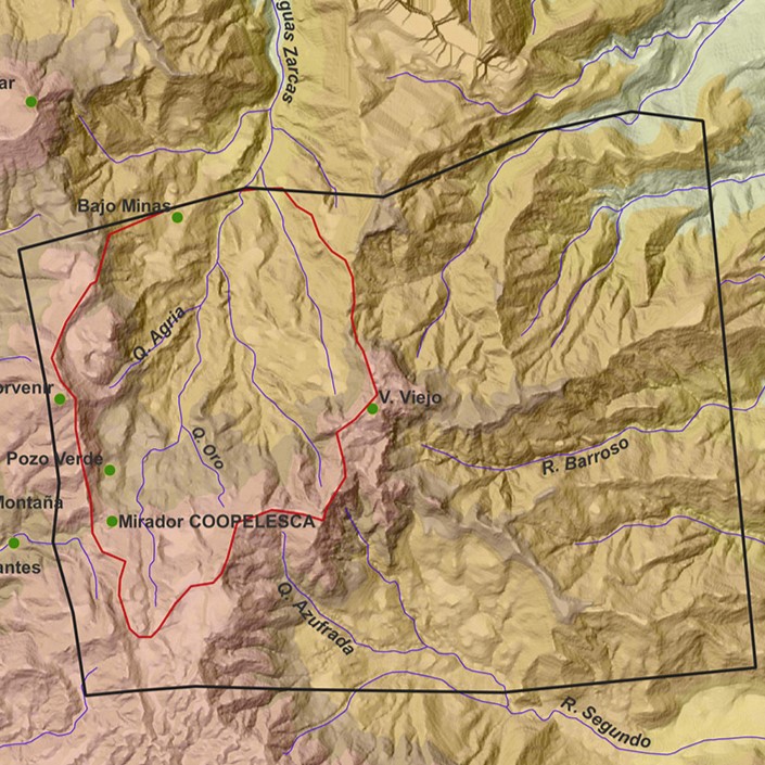
In July 2023, a significant landslide occurred in the Pozo Verde sector of Juan Castro Blanco National Park, triggering a series of mudflows and debris that affected the population of Aguas Zarcas in various ways. This article integrates geological observations, historical data collected from oral accounts, mineral identification through diffractometry, and the geomorphological photointerpretation of aerial photographs from 1981. These analyses show that this is not the first time a major landslide has occurred in the area. Oral accounts indicate that the affected area had already shown signs of instability since the 1970s and 1980s. Additionally, photointerpretation of the aerial photographs analyzed in the Geomatics Laboratory of the Central American School of Geology at the University of Costa Rica (UCR) reveals a landscape characteristic of slope instability. The area directly impacted by the landslide shows scars from previous landslides, and three independent bodies of instability were identified. Along the Aguas Zarcas and Barroso rivers, evidence of debris flow deposits from various small landslides, still present in 1981, was observed. Furthermore, the diffractometric analysis carried out at the UCR School of Chemistry on soil samples collected from the landslide yielded interesting mineralogical results related to hydrothermally altered clay groups, including montmorillonite, an expansive clay, although the expansion percentage was not determined. All these aspects together indicate that the headwaters of the Aguas Zarcas River have been a site susceptible to large landslides, making it crucial to maintain constant monitoring of the area.
References
Alvarado, G. E., Mora, R., y Peraldo, G. (2003). The June 2000 Arancibia Debris Avalanche and Block-slide, Costa Rica. Landslide News, 14–15, 29–32. https://www.researchgate.net/publication/351781222
Álvarez-Gutiérrez, Y., Montoya-Cañola, S. M., Rendón-Giraldo, D. A., y Caballero-Acosta, J. H. (2015). Análisis y diagnóstico de los fenómenos de inestabilidad que afectan el sector “La Bonita”, Amagá, Antioquia, Colombia. Boletín de Ciencias de La Tierra, 37, 35–44. https://doi.org/10.15446/rbct.n37.43757
Araya, R. (2004). Deslizamiento Arancibia, Puntarenas: junio del 2000. Serie: Hoy hace...
Betancourth, D., Gómez, J. F., Mosquera, J. C., y Tirado-Mejía, L. (2010). Análisis por difracción de Rayos X de rocas provenientes de Región Esmeraldífera. Scientia et Technica,XVI(44), 257–260.
Dóndoli, C. (1950). Informe sobre el yacimiento de azufre denominado “El Congo”. Universidad de Costa Rica (Trabajo reimpreso en 1965, Informes técnicos y notas geológicas, 19).
Garita, F. (1995). Toponimia de la Provincia de Cartago. Editorial de la Universidad de Costa Rica.
González, C. (1994). Temblores, terremotos, inundaciones y erupciones volcánicas en Costa Rica 1608 – 1910. Editorial Tecnológica de Costa Rica.
Huapaya, A. S., Rodríguez, E., y Ceciliano, A. (2021). Mapa geológico 1:50 000 Hoja 3346-IV Quesada. Dirección de Geología y Minas, Minae.
Montero, W., y Alvarado, G. E. (1995). El terremoto de Patillos del 30 de diciembre de 1952 (Ms = 5,9) y el contexto neotectónico de la región del volcán Irazú, Costa Rica. Revista Geológica de América Central, 18, 25–42. https://doi.org/https://doi.org/10.15517/rgac.v0i18.13522
Mora, R. (2000). El deslizamiento de las lagunas de Arancibia, Costa Rica: un desastre dos veces anunciado. EIRD Informa - América Latina y El Caribe, 2.
Peraldo, G. (2000). Los deslizamientos. En P. Denyer y S. Kussmaul (eds), Geología de Costa Rica (pp. 273-268). Editorial Tecnológica de Costa Rica.
Peraldo, G., y Molina, F. (1993). Reconstrucción histórica del deslizamiento de Puriscal. Revista Geológica de América Central, 16, 85–94. https://doi.org/https://doi.org/10.15517/rgac.v0i16.13273
Peraldo, G., y Rojas, E. (2000). Catálogo de deslizamientos históricos para Costa Rica, periodo 1772 – 1962. Informe Semestral Instituto Geográfico Nacional, 36, 123–171.
Peraldo, G., Badilla, E. (2024). Landslides of a Middle Reventazón Catchment lithological and topographic controls. En A. Quesada-Román (ed.), Landscapes and landforms of Costa Rica, World Geomorphological Landscapes (pp. 391-412). Springer.
Ramírez, O. (4 de septiembre de 1968). Desarrollo minero, riqueza para Costa Rica. La República, 6.
Salazar, M., Alvarado, G. E., Madrigal, J., y Monestel, Y. (2019). Deslizamientos históricos importantes en el Volcán Barva (Costa Rica) y su transformación en flujos de escombros volcánicos. Revista Geológica de América Central, 61, 107–119. https://doi.org/10.15517/rgac.v61i0.40090
##plugins.facebook.comentarios##

This work is licensed under a Creative Commons Attribution-NonCommercial-ShareAlike 4.0 International License.
Copyright (c) 2024 Giovanni Peraldo Huertas, Elena Badilla Coto, Leonardo Quesada Román


