

Keywords
Subduction
Earthquake statistics
Seismic energy
Seismic intensity
Sismicidad de Costa Rica
Subducción
Estadística sísmica
Energía sísmica
Intensidad sísmica
How to Cite


Abstract
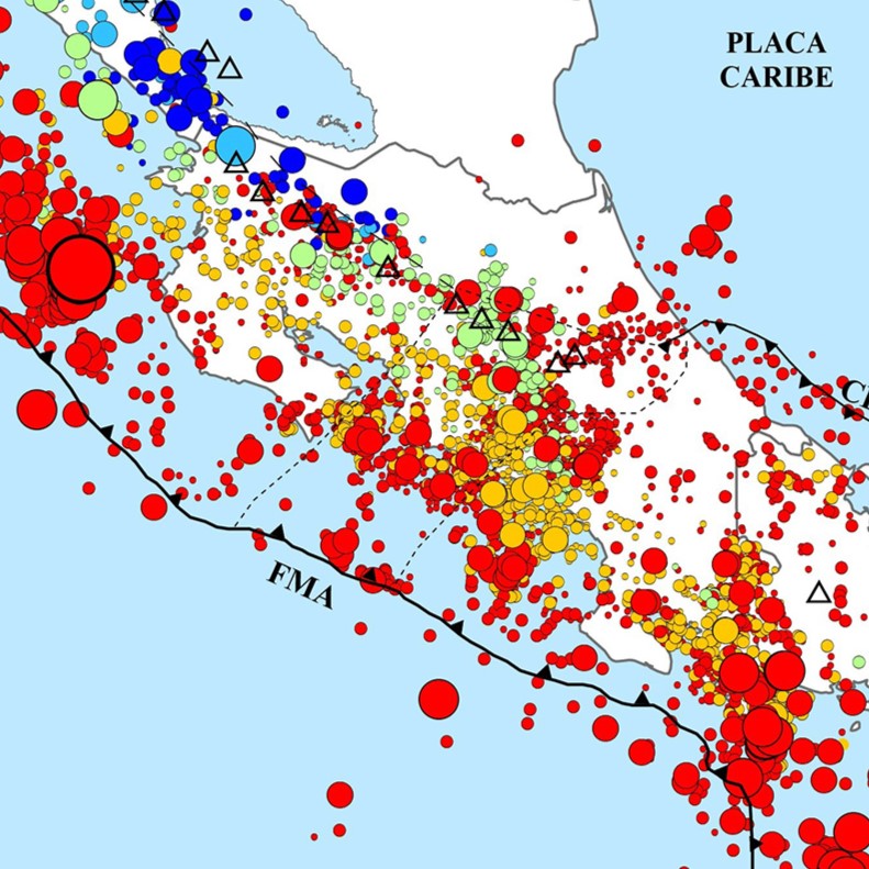
This study presents 139 new focal mechanisms calculated in the context of the annual seismicity review of 2024. In total, the National Seismological Network (RSN) located 5378 events, whose combined energy is equivalent to an earthquake of moment magnitude (Mw) 6.6. Only ~3.8 % (204) of the earthquakes were perceived by the population. The focal mechanisms and locations of these events allowed the earthquake source to be grouped into five categories: faulting in the Caribbean and Panama upper plates, interplate seismogenic zone of the Cocos plate, internal deformation of the subducted Cocos plate, faulting in the boundary between the Cocos and Nazca plates, and faulting in the Cocos plate prior to subduction. The shallow (< 35 km) earthquakes in the upper-plates and in the Coco-Nazca boundary occurred mainly on strike-slip faults, while those related to subduction were reverse. The ten most significant earthquakes felt in 2024 reached magnitudes of Mw 5.5-6.2. The maximum intensity was V, observed in very small areas near the epicenters of six earthquakes (Mw 4.9 and 6.2).
References
Adamek, S., Frohlich, C., y Pennington, W. D. (1988). Seismicity of the Caribbean-Nazca boundary: Constraints on microplate tectonics of the Panama region. Journal of Geophysical Research: Solid Earth, 93(B3), 2053-2075
Arroyo, I. G., y Linkimer, L. (2021a). Geometría de la zona sismogénica interplacas en el sureste de Costa Rica a la luz de la secuencia sísmica de Golfito del 2018. Geofísica Internacional, 60-1, 51-75. https://doi.org/10.22201/igeof.00167169p.2021.60.1.2026
Arroyo, I., y Linkimer L. (2021b). Modelo de velocidad sísmica unidimensional y características tomográficas del Caribe Sur de Costa Rica. Revista Geológica de América Central, 65, 1-15. https://doi.org/ 10.15517/rgac.v0i65.46696
Arroyo, M., Linkimer, L., y Arroyo, I. (2020). Recuento de la sismicidad en Costa Rica durante el 2019. Revista Geológica de América Central, 62, 116-133. https://doi.org/10.15517/rgac.v62i0.40639
Arroyo, I. G., Husen, S., y Flueh, E.R. (2014). The seismogenic zone in the Central Costa Rican Pacific margin: high-quality hypocentres from an amphibious network. International Journal of Earth Sciences, 103, 1747. https://doi.org/10.1007/s00531-013-0955-8
Atkinson, G., y Wald, D. (2007). “Did You Feel It?” intensity data: A surprisingly good measure of earthquake ground motion. Seismological Research Letters, 78(3), 362-368.
Boschini, L., I. M., Alvarado I., G. E., y Rojas Q., W. (1988). El terremoto de Buenavista de Pérez Zeledón (julio 3, 1983): evidencia de una fuente sismogénica intraplaca desconocida en Costa Rica. Revista Geológica de América Central, 8, 111-121.
Camacho, J., (2015). Caracterización geofísica y neotectónica de la falla Cote-Arenal, Costa Rica. (Tesis de Licenciatura). Universidad de Costa Rica.
Denyer, P., Montero, W., y Alvarado, G. (2003). Atlas Tectónico de Costa Rica. Editorial de la Universidad de Costa Rica.
DeShon, H.R., Schwartz, S. Y., Newman, A.V., González, V., Protti, M., Dorman, L. M., Dixon, T. H., Sampson, D. E., y Flueh, E. R. (2006). Seismogenic zone structure beneath the Nicoya Peninsula, Costa Rica, from three-dimensional local earthquake P- and S-wave tomography. Geophysical Journal International, 164, 1, 109–124. https://doi.org/10.1111/j.1365-246X.2005.02809.x
Diario Extra. (6 de junio de 2024). Seguidilla de sismos en Tilarán alerta a expertos. Diario Extra. https://www.diarioextra.com/noticia/seguidilla-de-sismos-en-tilaran-alerta-a-expertos
Gempa (2019). SeisComp 3 Real time data acquisition and processing. Gempa GmbH. Informe interno.
Fonseca, H. (17 de abril de 2024). Fuerte sismo sentido en gran parte del país. El Guardián. https://elguardian.cr/fuerte-sismo-sentido-en-gran-parte-del-pais/
Havskov, J., Voss, P. H., y Ottemöller, L. (2020). Seismological Observatory Software: 30 Yr of SEISAN. Seismological Research Letters, 91(3), 1846-1852. https://doi.org/10.1785/0220190313
Kolarsky, R. A., y Mann, P. (1995). Structure and neotectonics of an oblique subduction margin, southwestern Panama. En P. Mann (ed.), Geologic and Tectonic Development of the Caribbean Plate Boundary in Southern Central America (Geological Society of America Special Paper 295, pp. 225-233). The Geological Society of America, Inc. https://doi.org/10.1130/SPE295
Lienert, B. R., y Havskov, J. (1995). A computer program for locating earthquakes both locally and globally. Seismological Research Letters, 66(5), 26-36.
Linkimer, L., y Alvarado, G. E. (2014). Distribución espacio-temporal de la sismicidad sentida en Costa Rica (1976-2013) en el marco histórico del 30 aniversario (1982-2012) de la Red Sismológica Nacional (RSN: UCR-ICE). Revista Geológica de América Central, Número Especial 30 aniversario, 45-71. https://doi.org/10.15517/rgac.v0i0.16569
Linkimer, L., y Arroyo, I. (2020). Ciencia ciudadana y herramientas de comunicación en la Red Sismológica Nacional de la Universidad de Costa Rica. Revista Comunicación, 29(2), 2-21.
Linkimer L., Arroyo, M., y Arroyo, I. G. (2021). Sismicidad y ruido sísmico en Costa Rica durante la pandemia del año 2020. Revista Geológica de América Central, 64, 1-18. https://doi.org/10.15517/rgac.v0i64.46623
Linkimer, L., Fallas, C., y Arroyo, I. G. (2022). Estadística de la sismicidad del 2021 en Costa Rica. Revista Geológica de América Central, 66, 1-18, 2021. https://doi.org/10.15517/rgac.v0i66.50150
Linkimer, L., Fallas, C., y Arroyo, I. G. (2023). Sismicidad localizada por la Red Sismológica Nacional durante el 2022. Revista Geológica de América Central, 68(1), 1-18. https://doi.org/10.15517/rgac.2023.54122
Linkimer, L., Fallas, C., y Arroyo, I. G. (2024). Origen de los sismos sentidos en Costa Rica durante el año 2023. Revista Geológica de América Central, 70(1), 1-18. https://doi.org/10.15517/rgac.2024.58439
Linkimer, L., Arroyo, I. G., Alvarado, G., Arroyo, M., y Bakkar, H. (2018). The National Seismological Network of Costa Rica (RSN): An Overview and Recent Developments. Seismological Research Letters, 89(2A), 392-398. https://doi.org/10.1785/0220170166
Linkimer, L., Arroyo, I., Mora, M., Vargas, A., Soto, G. J., Barquero, R., Rojas, W., Taylor, W., & Taylor, M. (2013). El terremoto de Sámara (Costa Rica) del 5 de setiembre del 2012 (Mw 7,6). Revista geológica De América Central, 49, 73–82. https://doi.org/10.15517/rgac.v0i49.13104
Lücke, O., y Arroyo, I. G. (2015). Density Structure and Geometry of the Costa Rican Subduction Zone from 3-D Gravity Modeling and Local Earthquake Data. Solid Earth, 6, 1169-1183. https://doi.org/10.5194/se-6-1169-2015
Madrigal, L. M. (24 de julio de 2024a). Deslizamiento submarino causó tsunami en Punta Burica el 22 de julio, confirma Sinamot. Delfino.cr. https://delfino.cr/2024/07/deslizamiento-submarino-causo-tsunami-en-punta-burica-el-22-de-julio-confirma-sinamot
Madrigal, L. M. (12 de octubre de 2024b). Sismo con epicentro en Guanacaste sacude buena parte del país. Delfino.cr. https://delfino.cr/2024/10/sismo-con-epicentro-en-guanacaste-sacude-buena-parte-del-pais
Marshall, J. S., Fisher, D. M., y Gardner, T. W. (2000). Central Costa Rica deformed belt: Kinematics of diffuse faulting across the western Panama block. Tectonics, 19 (3), 468-492.
Matumoto, T., Ohtake, M., Latham, G., y Umaña, J. (1977). Crustal structure in Southern Central America. Bulletin of Seismological Society of America, 67, 121-133.
Ministerio de Planificación Nacional y Política Económica (Mideplan). (2018). Mapa de Division regional-cantonal. https://documentos.Mideplan.go.cr/share/s/KLpLoXCwT0yU96gKSI4PVQ
Montero, W. (1989). Sismicidad histórica de Costa Rica 1638–1910. Geofísica Internacional, 28, 531-559.
Montero, W. (2001). Neotectónica de la región central de Costa Rica: frontera oeste de la microplaca de Panamá. Revista Geológica de América Central, 24, 29-56.
Montero-Pohly, W. (2021). Los terremotos de Cuericí del 24 de abril de 1991 (Mw 6,1) y de Buenavista del 3 de julio de 1983 (Ms 6,3): dos rupturas contiguas de la falla División en el centro de Costa Rica. Revista Geológica de América Central, 65, 1–22.
Montero, W., Lewis, J.C., y Araya, M.C. (2017). The Guanacaste Volcanic Arc Sliver of Northwestern Costa Rica. Scientific Reports, 7, 1797. https://doi.org/10.1038/s41598-017-01593-8
Montero, W., Denyer, P., Barquero, R., Alvarado, G.E., Cowan, H., Machette, M., Haller, K., & Dart, R., (1998). Map and database of Quaternary faults and folds in Costa Rica and its offshore regions. USGS. Reporte preliminar.
Mora, M. M., y Peraldo, G. (2011). Análisis macrosísmico del terremoto de buena vista de Pérez Zeledón, 3 de julio de 1983 (ms = 6,1), Costa Rica. Revista geológica De América Central, 44. https://doi.org/10.15517/rgac.v0i44.3445
Peraldo, G., y Montero, W. (1994). Temblores del periodo colonial de Costa Rica (Primera ed.). Editorial Tecnológica.
Porras, J. L. Linkimer, L., Araya, C., Arroyo, M., Taylor, M., y Rojas, W. (2017). Sismicidad registrada por la RSN en el 2016. Revista Geológica de América Central, 56, 117-128, 2017. https://doi.org/10.15517/rgac.v0i56.29239
Porras, J. L., Linkimer, L., Arroyo, I., Arroyo, M., y Taylor, M. (2018). Actividad sísmica percibida en Costa Rica durante el 2017. Revista Geológica de América Central, 58, 203-2014. https://doi.org/10.15517/rgac.v58i0.32852
Porras, J. L., Linkimer, L., Arroyo, I., Arroyo, M., Taylor, M., y Fallas, C. (2019). La sismicidad del 2018 en Costa Rica. Revista Geológica de América Central, 60, 133-144. https://doi.org/10.15517/rgac.v2019i60.36468
Sánchez, S. (16 de febrero de 2024). Temblor de 4,8 grados en Pérez Zeledón. La Nación. https://www.nacion.com/sucesos/seguridad/temblor-de-48-grados-en-perez-zeledon/4DF3TB5BCJANDKMWEYXZYP5K3I/story/
Snoke, J., Munsey, J., Teague, A., y Bollinger, G. (1984). A program for focal mechanism determination by combined use of polarity and Sv-P amplitude ratio data. Earthquake Notes, 55, 15-20.
Stein, S., y Wysession, M. (2003). An introduction to Seismology, earthquakes, and earth structure. Blackwell Publishing.
Swissinfo. (08 de julio de 2024). Un sismo de 5,9 sacude la frontera entre Panamá y Costa Rica sin víctimas mortales. Swissinfo. https://www.swissinfo.ch/spa/un-sismo-de-5,9-sacude-la-frontera-entre-panam %C3 %A1-y-costa-rica-sin-v %C3 %ADctimas-mortales/83130790
United States Geological Survey (USGS). (s.f.). NEIC Catalog. (Catálogo de información sísmica). https://earthquake.usgs.gov/earthquakes/search
Wald, D. J., Wald, L., Worden, B., y Goltz, J. (2003). ShakeMap, a tool for earthquake response. USGS Fact Sheet FS-087-03. USGS.
Wald, D. J., Quitoriano, V., Worden, C. B., Hopper, M., y Dewey, J. W. (2011). USGS “Did You Feel It?” Internet-based Macroseismic Intensity Maps. Annals of Geophysics, 54(6), 688-707. https://doi.org/10.4401/ag-5354
Westbrook, G. K., Hardt, N. C., y Heath, R. (1995). Structure and tectonics of the Panama–Nazca boundary. En P. Mann (ed.), Geologic and Tectonic Development of the Caribbean Plate Boundary in Southern Central America (Geological Society of America Special Paper 295, pp. 225-233). The Geological Society of America, Inc. https://doi.org/10.1130/SPE295
##plugins.facebook.comentarios##

This work is licensed under a Creative Commons Attribution-NonCommercial-ShareAlike 4.0 International License.
Copyright (c) 2025 Lepolt Linkimer, Carolina Fallas, Ivonne G. Arroyo